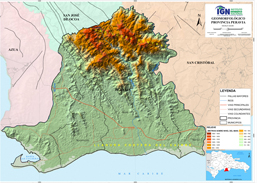
Environment
Peravia Province Geomorphological Map
Geomorphological map of the Peravia province, which provides information on the forms and physical characteristics of the relief that the land surface has. Useful for planning, land use planning and disaster risk management, among others.
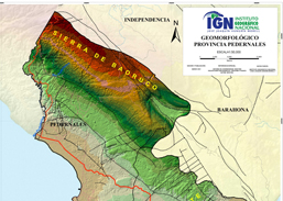
Environment
Pedernales Province Geomorphological Map
Geomorphological map of the Pedernales province, which provides information on the forms and physical characteristics of the relief that the land surface has. Useful for planning, land use planning and disaster risk management, among others.
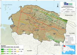
Environment
Monte Cristi Province Geomorphological Map
Geomorphological map of the Monte Cristi province, which provides information on the forms and physical characteristics of the relief that the land surface has. Useful for planning, land use planning and disaster risk management, among others.
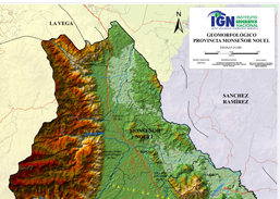
Environment
Monseñor Nouel Province Geomorphological Map
Geomorphological map of the Monseñor Nouel province, which provides information on the forms and physical characteristics of the relief that the land surface has. Useful for planning, land use planning and disaster risk management, among others.
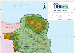
Environment
María Trinidad Sánchez Province Geomorphological Map
Geomorphological map of the María Trinidad Sánchez province, which provides information on the forms and physical characteristics of the relief that the land surface has. Useful for planning, land use planning and disaster risk management, among others.
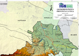
Environment
La Vega Province Geomorphological Map
Geomorphological map of the La Vega province, which provides information on the forms and physical characteristics of the relief that the land surface has. Useful for planning, land use planning and disaster risk management, among others.
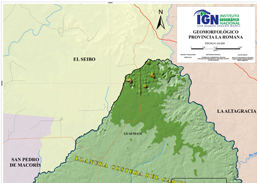
Environment
La Romana Province Geomorphological Map
Geomorphological map of the La Romana province, which provides information on the forms and physical characteristics of the relief that the land surface has. Useful for planning, land use planning and disaster risk management, among others.
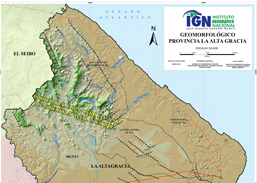
Environment
La Altagracia Province Geomorphological Map
Geomorphological map of the La Altagracia province, which provides information on the forms and physical characteristics of the relief that the land surface has. Useful for planning, land use planning and disaster risk management, among others.
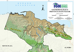
Environment
Inglés Geomorphological Map of Hato Mayor Province
Geomorphological map of the Hato Mayor province, which provides information on the forms and physical characteristics of the relief that the land surface has. Useful for planning, land use planning and disaster risk management, among others.
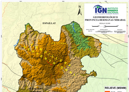
Environment
Hermanas Mirabal Province Geomorphological Map
Geomorphological map of the Hermanas Mirabal province, which provides information on the forms and physical characteristics of the relief that the land surface has. Useful for planning, land use planning and disaster risk management, among others.
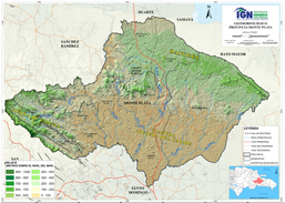
Environment
Geomorphological Map Monte Plata Province
Geomorphological map of the Monte Plata province, which provides information on the forms and physical characteristics of the relief that the land surface has. Useful for planning, land use planning and disaster risk management, among others.
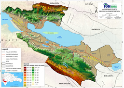
Environment
Geomorphological Map Independencia Province
Geomorphological map of the province Independencia, which provides information on the forms and physical characteristics of the relief that the land surface has. Useful for planning, land use planning and disaster risk management, among others.